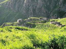
Zangilan District (Azerbaijani: Zəngilan rayonu) is a district in south-west Azerbaijan with the administrative centre being the city of Zangilan.
It was founded in 1930. Location is in the southeast of Smaller Caucasus, on left bank of Araz River. It has borders with Armenia in the west and the northwest, Iran Islamic Republic in the south and southeast. The area makes 707 км². The Administrative center is the Zangilan town. This region located in an area where East and the West unite, was one of coordinating points in trade. Proofs of ancient history of region are fortresses, the patrol points, material-cultural monuments and samples which have been found at archeological excavations, ancient coins and household ware. Many graves were found in territory of region at carrying out of agricultural works in 60s and tens of coins concerning IV-II to centuries. It was known during archeological excavations it became known that the territory is rich on archaeological and historical monuments.
Zangilan district, which included 1 city, 1 settlement and 83 villages, had 9 preschool institutions, 19 primary and 15 secondary schools, one vocational school, one music school, 35 libraries, 8 cultural centers, 23 club-houses.

Zangilan's territory is also rich in archaeological and architectural monuments, the largest of which is the ruins of the medieval city, known as "Shahri Sharifam".
The city is located in the very convenient place from the natural, geographical and strategic viewpoint; from the West it is covered by a mountain chain, from the east – steep river bank of Hakari.

It was known that the city settled down on the basic trade road of Southern Caucasus. The first excavation has found out cultural strata here, which gives the grounds to assert that people has lived here since IX century. The special place in the city’s economy was occupied by rice cultivation that is proved by rice storage found in the city. One of architectural monuments is the monument of Shahri-Sharifan located in Sharifan village. Most part of this monument has been destroyed and washed off as a result of a descent lodging in Hakari River.
There are dozens of tombs with different historical ornaments on the basin of Sharaka flow through the region. Eight-point Yahya Ibn Muhammed tomb (Azerbaijani: Məmmədbəyli türbəsi) one of these tombs located in Mammadbayli village of Zangilan differs from the others for its architectural-constructive shape. There is medieval cemetery around the tomb.

The mausoleum was built in 1305, by architect Ali Majid ad-Din on the Silk Road. In 1975, there was held cleansing works in underground part of the mausoleum in the result of which a sepulcher was found out.
On October 29, 1993, the rayon came under the control of the Nagorno-Karabakh Defence Army during the First-Karabakh War.
All the Azerbaijani inhabitants of the city were forcefully driven out. During the period of Armenian control, the town was renamed to Kovsakan. In 2005 the population of the town was less than 400. Armenians also destroyed important historical monuments, subsoil assets, rich water sources in Zangilan region, forests burned. Thousands of martyrs were killed in heavy fighting.
On 20 October 2020, the President of Azerbaijan, Ilham Aliyev, announced that Azerbaijani military forces recaptured some settlements in Zangilan district, namely, Havali, Zarnali, Mammadbayli, Hakari, Sharifan, Mughanli villages, as well as Zangilan city itself. On October 21, 2020, it was announced that Minjivan settlement and 12 more villages of Zangilan district have been recaptured. Azerbaijani authorities announced the capture of 13 more villages and Aghband settlement of Zangilan district on October 22, 2020.


No comments:
Post a Comment